


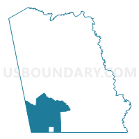
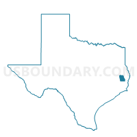
Voting District 0004, Tyler County, Texas
About
Outline

Summary
| Unique Area Identifier | 677861 |
| Name | Voting District 0004 |
| County | Tyler County |
| State | Texas |
| Area (square miles) | 95.54 |
| Land Area (square miles) | 95.53 |
| Water Area (square miles) | 0.01 |
| % of Land Area | 99.99 |
| % of Water Area | 0.01 |
| Latitude of the Internal Point | 30.60070590 |
| Longtitude of the Internal Point | -94.47556150 |
Maps

Graphs
Select a template below for downloading or customizing gragh for Voting District 0004, Tyler County, Texas


Neighbors
Neighoring Voting District (by Name) Neighboring Voting District on the Map
- Voting District 0001, Tyler County, TX
- Voting District 0003, Tyler County, TX
- Voting District 0006, Tyler County, TX
- Voting District 0008, Hardin County, TX
- Voting District 0013, Polk County, TX
- Voting District 0016, Tyler County, TX
Top 10 Neighboring County Subdivision (by Population) Neighboring County Subdivision on the Map
- Livingston-Onalaska CCD, Polk County, TX (40,554)
- Kountze CCD, Hardin County, TX (12,508)
- Woodville CCD, Tyler County, TX (10,417)
- Saratoga-Batson CCD, Hardin County, TX (3,682)
- Warren CCD, Tyler County, TX (3,005)
Top 10 Neighboring Place (by Population) Neighboring Place on the Map
Top 10 Neighboring Unified School District (by Population) Neighboring Unified School District on the Map
- Woodville Independent School District, TX (11,154)
- Kountze Independent School District, TX (8,137)
- Warren Independent School District, TX (5,691)
- Big Sandy Independent School District, TX (2,158)
Top 10 Neighboring State Legislative District Lower Chamber (by Population) Neighboring State Legislative District Lower Chamber on the Map
- State House District 18, TX (150,998)
- State House District 12, TX (149,506)
- State House District 19, TX (139,948)
Top 10 Neighboring State Legislative District Upper Chamber (by Population) Neighboring State Legislative District Upper Chamber on the Map
Top 10 Neighboring 111th Congressional District (by Population) Neighboring 111th Congressional District on the Map
Top 10 Neighboring Census Tract (by Population) Neighboring Census Tract on the Map
- Census Tract 303, Hardin County, TX (10,130)
- Census Tract 9502, Tyler County, TX (7,895)
- Census Tract 2101.02, Polk County, TX (6,526)
- Census Tract 301, Hardin County, TX (3,682)
- Census Tract 9505, Tyler County, TX (3,005)
Top 10 Neighboring 5-Digit ZIP Code Tabulation Area (by Population) Neighboring 5-Digit ZIP Code Tabulation Area on the Map
- 77351, TX (32,517)
- 75979, TX (11,423)
- 77625, TX (8,489)
- 77664, TX (2,681)
- 77663, TX (1,353)
- 77624, TX (856)